Sky Stacks: What Makes Some Clouds Stack Up Like Perfectly Smooth Flying Saucers
Ever spotted clouds that look like a stack of sleek, flying saucers? Often mistaken for UFOs, these captivating and otherworldly formations are actually a fascinating meteorological phenomenon.

Too Long; Didn't Read
Clouds that look like stacked flying saucers are not UFOs; they are a real weather phenomenon called lenticular clouds, formed by unique atmospheric conditions.
Sky Stacks: What Makes Some Clouds Stack Up Like Perfectly Smooth Flying Saucers?
Have you ever gazed at the sky and spotted clouds that seem to defy earthly norms, appearing like a stack of sleek, polished flying saucers or a pile of ethereal pancakes? These captivating formations, often mistaken for UFOs due to their otherworldly appearance, are a fascinating meteorological phenomenon. Far from being alien spacecraft, these are known as lenticular clouds, and their presence tells a unique story about the invisible movements and conditions within our atmosphere. Understanding what makes some clouds stack up like perfectly smooth flying saucers unveils the intricate dance between wind, terrain, and moisture, offering a glimpse into the dynamic forces shaping our skies. This post will delve into the science behind these stunning aerial displays.
What Are These Saucer-Shaped Clouds?
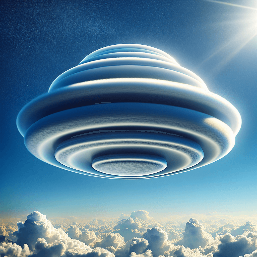
The official name for these distinctive clouds is Altocumulus lenticularis, or lenticular clouds, derived from the Latin word "lenticularis" meaning "lens-shaped." They are stationary, orographic (mountain-related) wave clouds that form at high altitudes, typically aligned perpendicular to the wind direction. Their smooth, polished appearance is due to the very fine ice crystals or water droplets they are composed of, and their sharp edges clearly define their unique shape. Their often-isolated nature and unusual form have, for decades, led to them being reported as unidentified flying objects, adding a layer of mystique to their scientific explanation.
The Recipe for Lenticular Clouds: Mountains and Wind
The formation of lenticular clouds is a specific process requiring a particular set of atmospheric ingredients and conditions.
The Key Ingredient: Orographic Lift
The primary trigger for lenticular cloud formation is orographic lift. This occurs when a strong, stable, and moist air current encounters a significant topographical barrier, such as a mountain range or even a large hill. As the air is forced to flow up and over this barrier, it undergoes changes that can lead to cloud formation.
Stable Air Layers are Crucial
For lenticular clouds to form, the atmosphere must be stable. In a stable atmosphere, air parcels resist vertical motion. If pushed upwards, they tend to return to their original level once the force is removed. This stability is key because it means that as air flows over a mountain, instead of rising continuously and forming convective clouds (like cumulus), it oscillates in a wave-like pattern on the leeward (downwind) side of the mountain.
How the "Waves" Form
This oscillation creates what are known as mountain waves or lee waves. Imagine water flowing over a submerged rock in a stream; you'll see standing waves or ripples forming downstream from the rock. Air behaves similarly. As stable air is forced over the mountain crest, it descends on the other side, but due to its stability and momentum, it overshoots its original level and then rises again, repeating this up-and-down motion in a series of waves that can extend for many miles downwind. Lenticular clouds form at the crests of these standing waves.
Condensation at the Crests
As a parcel of moist air rises within the wave crest, it expands and cools adiabatically (without heat exchange with its surroundings). If this air cools to its dew point temperature, the water vapor within it condenses into tiny water droplets or ice crystals, forming a visible cloud. Conversely, as the air descends into the trough of the wave, it compresses and warms, causing the cloud droplets or ice crystals to evaporate. This continuous process of condensation at the wave crest and evaporation in the trough is why lenticular clouds appear stationary, even though wind is constantly blowing through them.
Why the "Stacked" Appearance?
The truly spectacular "stacked" appearance, resembling a pile of pancakes or multiple saucers, occurs when there are several alternating layers of moist and dry air aloft, all affected by the same mountain wave system.
- Each moist layer, when lifted by the wave to its condensation level, will form its own lenticular cloud.
- If these moist layers are separated by drier air, you'll see distinct, separate cloud lenses stacked one above the other, each corresponding to a different altitude where conditions are right for condensation. The result is a breathtaking multi-layered structure, all perfectly aligned by the atmospheric wave.
Where and When to Spot Lenticular Clouds
Lenticular clouds are most commonly observed in mountainous regions across the globe, such as the Rockies, the Andes, the Alps, and the Himalayas. However, they can occasionally form over smaller hills if the atmospheric conditions are just right. They are often most prevalent during the winter or spring when winds aloft tend to be stronger and more consistent. The key indicators for their potential formation are strong, steady winds blowing perpendicular or nearly perpendicular to a mountain range, coupled with stable air containing sufficient moisture at the wave-crest altitudes.
More Than Just a Pretty Sight: Implications
While visually stunning, lenticular clouds also have practical implications:
- For Pilots: These clouds often signify severe turbulence, known as mountain wave turbulence. While glider pilots sometimes seek out the rising air in these waves for lift (a phenomenon called "wave soaring"), commercial and general aviation pilots are cautious, as the turbulence can be hazardous.
- For Weather Forecasting: The presence of lenticular clouds indicates strong winds at high altitudes and a stable atmospheric layer, which can be useful information for meteorologists.
Conclusion
The sight of clouds stacked like perfectly smooth flying saucers is a remarkable natural spectacle, born from a precise interplay of wind, terrain, and atmospheric stability. These lenticular clouds, scientifically known as Altocumulus lenticularis, are formed when stable, moist air is forced over mountains, creating standing waves where air cools and condenses at the crests. The iconic stacked appearance arises when multiple layers of moist air at different altitudes participate in this wave motion. More than just a visual marvel, they serve as indicators of powerful atmospheric dynamics. So, the next time you spot these otherworldly formations, you’ll appreciate the beautiful science sculpting these aerial masterpieces.