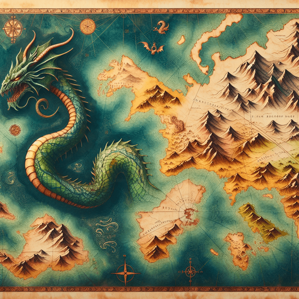
Here Be Dragons: Why Old Maps Are Filled With Sea Monsters
Ever wonder why ancient maps feature fearsome krakens and serpentine beasts in unexplored oceans? Uncover the real story behind why cartographers chose to populate the unknown with monsters.

Too Long; Didn't Read
Sea monsters on old maps served as warnings for dangerous, unexplored waters, reflected popular sailor myths, and filled the empty spaces on the chart where knowledge ended and speculation began.
Here Be Dragons: Unraveling Why Old Maps Often Feature Sea Monsters in Unexplored Ocean Areas
Ever pored over an ancient map, marveling at its faded coastlines and elegant script, only to find your eye drawn to a fearsome kraken engulfing a ship or a serpentine beast frolicking in an otherwise empty ocean expanse? These fantastical creatures are a common feature on historical charts, particularly in unexplored waters. But why did cartographers, tasked with representing the known world, populate their maps with such imaginative and often terrifying beings? This blog post delves into the intriguing reasons why old maps often feature sea monsters in unexplored ocean areas, revealing a blend of fear, folklore, artistic license, and practical cartographic tradition.
Main Content
The "Horror Vacui": Filling the Empty Spaces
Early cartographers, much like artists of their time, often grappled with a concept known as horror vacui—Latin for 'fear of empty spaces.' Unexplored oceans represented significant knowledge gaps. To avoid implying ignorance or incompleteness, mapmakers filled these voids with decorative elements like sea monsters. These served as dramatic placeholders, transforming a lack of information into a visually stimulating, albeit speculative, depiction of what might lie beyond the known world. These creatures weren't just random doodles; they visually encapsulated the profound mystery and perceived danger lurking beyond familiar shores.
Whispers from the Waves: Sailor's Yarns and Misidentified Marvels
For centuries, primary information about distant oceans came from sailors' tales. These accounts, relayed after perilous voyages, were often colored by fear, exhaustion, and the natural human tendency for embellishment. A fleeting glimpse of a giant squid's tentacle, the immense, unfamiliar back of a breaching whale, or the strange appearance of a walrus in icy northern waters could be misinterpreted and exaggerated into a terrifying sea serpent or a ship-crushing leviathan. Lacking scientific expeditions to verify such claims, cartographers incorporated these dramatic 'eyewitness' reports and vivid descriptions into their maps, lending a sense of perceived authenticity to the depicted dangers in unknown waters.
More Than Just Monsters: Artistry, Symbolism, and Status
Beyond filling blanks, sea monsters added significant artistic and symbolic value to maps. In an era when maps were often expensive, handcrafted items commissioned by wealthy patrons, royalty, or academic institutions, aesthetic appeal was paramount. Elaborate illustrations, including intricately drawn and fearsome sea creatures, could elevate a map from a mere navigational tool to a coveted work of art and a symbol of status or learning. Symbolically, these monsters could represent:
- The inherent perils and unpredictability of the unknown sea.
- Untamed, powerful forces of nature, sometimes viewed as divine or chaotic.
- The exotic and wondrous 'otherness' of distant, unexplored parts of the world.
Showcasing such details also allowed cartographers to display their artistic skill and classical knowledge, thereby enhancing the map's (and their own) prestige.
Cartographic Warnings: "Here Be Dangers"
While many depictions were fantastical, some sea monsters also served a practical, if indirect, warning function. Placing a fearsome beast in a particular region of the ocean could subtly indicate to navigators:
- Generally dangerous waters: Areas reputed for treacherous currents, frequent storms, hidden reefs, or where ships had mysteriously vanished.
- Unexplored territory: A clear visual cue that the area lay beyond the boundaries of known and relatively safe navigation.
These creatures acted as a more dramatic and memorable form of "Here Be Dragons" (a phrase popularly associated with old maps, though its literal use is rare), visually communicating risk in a way that simple notations might not. They transformed abstract danger into a concrete, imaginable threat.
The Ebbing Tide: Scientific Advancement and the Disappearance of Sea Monsters
The prevalence of sea monsters on maps began to decline significantly with the Age of Enlightenment and the rise of systematic scientific exploration from the 17th century onwards. As voyages meticulously charted more of the globe with increasing accuracy, and as the nascent field of marine biology began to scientifically classify and understand ocean life, the great unknown expanses of the ocean shrank.
- Scientific expeditions: Voyages, like those led by Captain James Cook, provided more precise geographical data and rational observations of marine fauna, debunking many ancient myths.
- Improved cartographic techniques: The development of more sophisticated surveying methods, chronometers for determining longitude, and a scientific ethos fostered maps that prioritized accuracy and empirical data over artistic embellishment.
Blank spaces on maps increasingly came to signify areas genuinely yet to be surveyed, rather than the supposed lairs of mythical beasts. The demand shifted from ornate, decorative maps to more utilitarian, scientifically robust charts, and the sea monsters were gradually replaced by factual hydrographic data like depth soundings and current notations.
Conclusion
So, the sea monsters adorning old maps were far more than just whimsical doodles. They were a complex tapestry woven from the fear of the unknown, embellished sailors' tales, artistic expression, symbolic representation, and even a form of cartographic shorthand for danger. These illustrations offer us a valuable glimpse into the mindset of past eras, reflecting humanity's evolving understanding of the world and the immense courage it took to explore it. While our modern maps are devoid of such fantastical beasts, these ancient cartographic creatures remain a testament to the enduring human fascination with mystery and the uncharted territories that once lay just beyond the horizon, reminding us of a time when the world felt infinitely larger and more wondrous.